PROJECT PORTFOLIO
 Client: Worldwide Fund for Nature (WWF)
Date: 2019 – 2020
Spatial scope: Southern Drakensberg Strategic Water Source Area, KZN, South Africa
Project Summary: The Strategic Water Source Areas (SWSAs) of South Africa are key catchment areas that supply a disproportionate (i.e. relatively large) volume of mean annual surface water runoff in relation to their size, and so are considered nationally important (Le Maitre et al 2018). They are recognised in the National Water Resources Strategy (NWRS-II) as “strategic national assets that are vital for water security”. Despite their importance, detailed protection and restoration plans are lacking. Importantly, there is a is a lack of detailed guidance on what and how to monitor and report on the state and functioning of the social-ecological systems in these areas.
The broad aim of the ‘State of the Sources’ project is to address the lack of a consistent and repeatable method for monitoring and reporting on the state of SWSAs, to be able to gather this information into a single reporting product and to demonstrate the value of sharing this through a readily accessible internet-based platform.
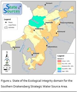
This project piloted a monitoring and reporting framework in the Southern Drakensberg Strategic Water Source Area (SDSWSA). It described the state of this source area in terms of 53 indicators which are aggregated up into 40 Dimensions, which are also aggregated up into eight Domains. Finally, a Total Framework Aggregation score is calculated for the SDSWSA.
Project outputs:
Reports can be downloaded here:
- Status Quo report
- Monitoring and Reporting Framework
- State of the Sources – Southern Drakensberg.
 Client: South African National Biodiversity Institute (SANBI)
Date: 2021 – 2023
Spatial scope: Berg/Breede and Greater uMngeni demonstration catchments, South Africa.
Project Summary: The Ecological Infrastructure for Water Security project (EI4WS) is a five-year project aimed at unlocking development finance to secure and where necessary rehabilitate Ecological Infrastructure (EI) in two critical catchments – the Greater uMngeni catchment (combined uMngeni River, upper Mooi River and upper Mkhomazi River catchments – all linked through existing or planned inter-basin transfers) in KwaZulu-Natal and the Berg-Breede Catchment in the Western Cape.
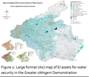
A very important component of this work is to establish a consolidated and widely accepted map of EI for each of the two demonstration catchments. A consolidated EI map is an important multi-purpose tool for various applications such as such as compiling ecological infrastructure asset accounts, informing Ecological Infrastructure Investment Frameworks and Management Plans at the catchment level, including ecological infrastructure in spatial biodiversity plans, and mainstreaming of EI into water resources management plans, Catchment Management Strategies, monitoring programmes and strategic (such as municipal Spatial Development Frameworks) and project level (such as Environmental Impact Assessments) environmental management tools and frameworks. Of specific relevance and importance to the EI4WS project is that a consolidated EI map will inform the development of an Ecological Infrastructure Management Plan (EIMP) for each of the demonstration catchments which is a key deliverable of the project.
EI is an evolving concept and there are a wide number of features in a landscape which can be considered EI. This project is focused on EI assets for water security. The following features have been selected for inclusion in the consolidated map of EI Assets for Water Security:
- Rivers
- Wetlands
- Riparian Areas
- Local Water Source Areas
- Strategic Water Source Areas
As part of this work, GeoNest was responsible for the development of a number of new spatial data products. These included:
- River channel polygons for all 1:50 000 river features with stream width based on stream order including condition categories of Natural / Near Natural and Modified
- Riparian areas as stream order-based buffers of river channels including condition categories of Natural / Near Natural and Modified
- Local water source areas including condition categories of Natural / Near Natural and Modified
Large format (A0) maps were developed for each of the demonstration catchments.
Client: OKACOM (funded by the European Union)
Date: 2019 – 2022
Spatial scope: The Cubango-Okavango River Basin (Angola, Namibia and Botswana).
Project Summary: The project was implemented across a number of Terms of References (ToRs) of which GeoNest personnel were involved in four of these.
ToR 3 – Enhancement of the DRIFT model to integrate DRIFT Land: The Integrated Cubango-Okavango River Basin (CORB) DRIFT is an ecosystem-based modelling platform for use to predict the ecological and social implications of planning and management activities that alter the flow of water or sediment in the river; land use and/or human population densities alongside the river; and the use of river resources through regulation and/or governance. The outputs of the Integrated CORB DRIFT DSS are semi-quantitative and based on existing data and expert knowledge. The Integrated CORB DRIFT is an integration of a newly constructed ‘DRIFT-LAND’ module into an update of an existing ‘DRIFT-WATER’.
ToR 4 – Establish links to national and other databases: Information management is crucial to the effective joint management of the Cubango-Okavango River Basin (CORB), and linking and harmonising relevant databases between member states and between member states and The Permanent Okavango River Basin Water Commission (OKACOM) provides a foundation of common information from which effective, efficient, data/evidence-based decision making can be implemented. Harmonisation of databases across Member States and across different institutions is however a complex task. Each of the Member States’ institutions collects a different set of data using different methods and manages and stores this data in a different way. Indeed, different users within a single institution can manage data differently and present a challenge to harmonisation. This Terms of Reference (ToR) aims to identify critical data that are required for joint basin management and to identify mechanisms by which such data can be efficiently shared across Members States and with OKACOM in a common format.
ToR 5 – Rules and procedures on the sharing of data and information for the Cubango-Okavango river basin: The overall objective of these Rules and Procedures is to ensure that relevant and quality assured data and information are shared in a timely manner between the Member States in order to enable the Member States – either individually, or jointly through OKACOM – to take informed decisions in relation to the planning, management and sustainable development of the shared water resources in the Cubango-Okavango River Basin. GeoNest personnel were involved in the drafting of this document having input into the nature of information that should be shared, and the mechanisms by which it should be shared.
ToR 13 – Decision Support System Operationalisation: Over the past 15 years, various projects have generated or collated datasets, documented studies and created models or scenarios that would be of value if they could be equally accessed both within OKACOM and the Member States more generally. In addition, the Rules and Procedures on the Sharing of Data and Information for the Cubango-Okavango River Basin has been finalised in 2020 and provides an agreed framework for the regular update and sharing of Member States information. TOR 13 aimed to address he accessibility of information and data through the development of the DSS. The DSS provides access to the data sets generated or collected over time and provides access to documentation and results from previous studies, as well as to applicable models and scenarios. The DSS provides a user-centric platform for the dissemination of this information and provides clear and intuitive dashboards of the time series, spatial and other data types provided for under the data-sharing rules and procedures. GeoNest personnel were centrally involved in the process of developing the DSS architecture and in defining use cases, users and their roles and responsibilities.
Client: Umgeni Water (Bulk water supplier in central KZN, South Africa)
Date: 2020 – 2022
Spatial scope: The uMngeni River catchment, KZN, South Africa.
Project Summary: The use of unmanned aerial vehicles (UAVs) has expanded dramatically across a variety of sectors in the last two decades. This list includes a range of applications supporting various aspects of environmental management. Catchment management is an area of environmental management that has great potential to benefit from the use of multispectral sensors mounted on UAVs particularly the potential for a wide range of data to be generated at limited cost. For this reason, a study was initiated in the uMngeni Catchment, to investigate the feasibility of the use of multispectral sensors deployed using UAVs in undertaking some key tasks. These include:
- Monitoring selected water quality parameters:
- Total suspended sediments
- Chlorophyll A
- Detecting and monitoring aquatic weeds
- Assessing riparian vegetation (buffer) integrity
- Identifying and locating infrastructure failures:
- Leaking water pipes
- Surcharging sewer manholes and sewer leaks.
The feasibility study demonstrated a high level of potential for monitoring suspended sediments and for monitoring aquatic weeds.
Client: Umgeni Water (Bulk water supplier in central KZN, South Africa)
Date: 2020 – 2022
Spatial scope: The uMngeni River catchment, KZN, South Africa.
Project Summary:
GeoNest (Pty) Ltd. is proudly carbon neutral in 2023 and supports a just transition to a green global economy
#ClimateChangeIsReal


